AZT Race GPS Data
The ride begins near border monument 103, see the FAQ page for an area map. New changes to both routes for 2026. *See the Announcements page for maps of each area – new routing will appear as the red line, old route is blue.
Northbound (Grand Depart & ITT) GPX files:
AZT300_2026_v5 (July 20, 2026) *See Note below* [GPX format] Simplified [GPX 10k Version]
AZT800_2026_v4 (July 20, 2026) [GPX format] Simplified [GPX 10k Version]
AZT800_2026_v5_Flagstaff_Finish (July 22, 2026) [GPX format] Note: This is a 10k file.
NOTE: There is a detour at the top of Mt. Lemmon until August 1, 2026. Sunset trail is closed to access, use the paved detour here: [GPX format]
Southbound (ITT Only) GPX Files:
AZT300_SB_XL_202X_v1 (TBD) [GPX format] Simplified [GPX 10k Version]
AZT800_SB_XL_2025_v2 (September 26, 2025) [GPX format] Simplified [GPX 10k Version]
Lemmon Pusch Lite [GPX format] *This is an optional route for 300 northbound riders who want an extra challenge. No time bonus is given for this. It utilizes the official AZT Pusch Ridge Wilderness Bypass: Bug Springs, Green Mtn., Incinerator Ridge, Kellogg trails and the Mt. Bigelow access road. This is extremely difficult, mostly hike-a-bike and generally not recommended. However, it is dirt that is officially signed AZT and not pavement. Proceed with caution.
Legacy AZT to Patagonia [GPX format] *This route is legal to use for the race if you want to bypass the daylight restrictions on the private ranch land between miles 52.5 & 54.5 (the final 2 miles before reaching SR82) of the published routes. It is longer and more difficult. Leaving Patagonia this route uses the Train Track Trail to rejoin the AZT at the SR82 underpass.
AZTR snow detours [GPX format]
All files (including previous years) are in the GPX directory. There are also pre-simplified (10k) versions.
See track uploading tutorial for help getting the GPX file onto your GPS.
100% of proceeds are donated to the ATA.
AZT 300/800 cue sheets
Mileage cues – AZT300 / AT800 Cues [Google Docs]
Warning: The cues are written using GPS mileage (Full resolution gpx, so expect them to be overestimates, compared to the 10k gpx file).
Warning 2: The cues are not as detailed when the route is on the AZT. For detours expect high detail, but otherwise it’s up to you to stay on the Arizona Trail. GPS and maps are highly recommended. See aztrail.org for detailed info on the trail, maps, current conditions and water sources.
Route Checklist for Section Riders
These spreadsheets help keep track of miles completed if riding the routes as a series of day rides or short bikepacking trips. When complete, you become eligible for the finishers patch & sticker. This is similar to the ATA’s belt buckle upon completing the trail over months or years. No matter how long it takes, it’s worth it!!
AZT300 Checklist
AZT800 Checklist
Resources
AZT Bikepacking Guide by Craig Fowler
The AZT bikeable passages by John Schilling
The Arizona Trail Association’s Mountain Biking page
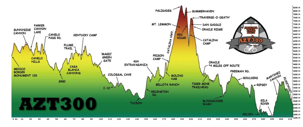
AZT 300 Route Description
The race starts at border monument 103. It follows the border fence for a short bit then turns northeast. It follows some dirt roads to the north end of Passage 1 where it officially joins the Arizona Trail leading back to Parker Canyon Lake via Sunnyside Canyon. The route then traverses up & down through the Canelo Hills to SR82. This ~32 mile section of primarily singletrack will give racers a taste of what’s to come. Expect some hike-a-bike, right off the bat. Elevations range from 4500 to 6000 feet.
Riders pass under SR82 and begin the Casa Blanca Canyon segment passing by El Pilar Spring. Route continues to Gardner Canyon — just in time for the oh-so-sweet Flume Trail.
The route follows the AZ Trail through Kentucky Camp and onto Las Colinas and Cienega passages of the trail. The race then hits pavement on Old Spanish Trail to detour around Saguaro National Park (wilderness). It passes through the east side of Tucson, where grocery stores, restaurants and even bike shops provide opportunity to refuel and repair. Tucson is almost the halfway point on the route, at roughly 120 miles.
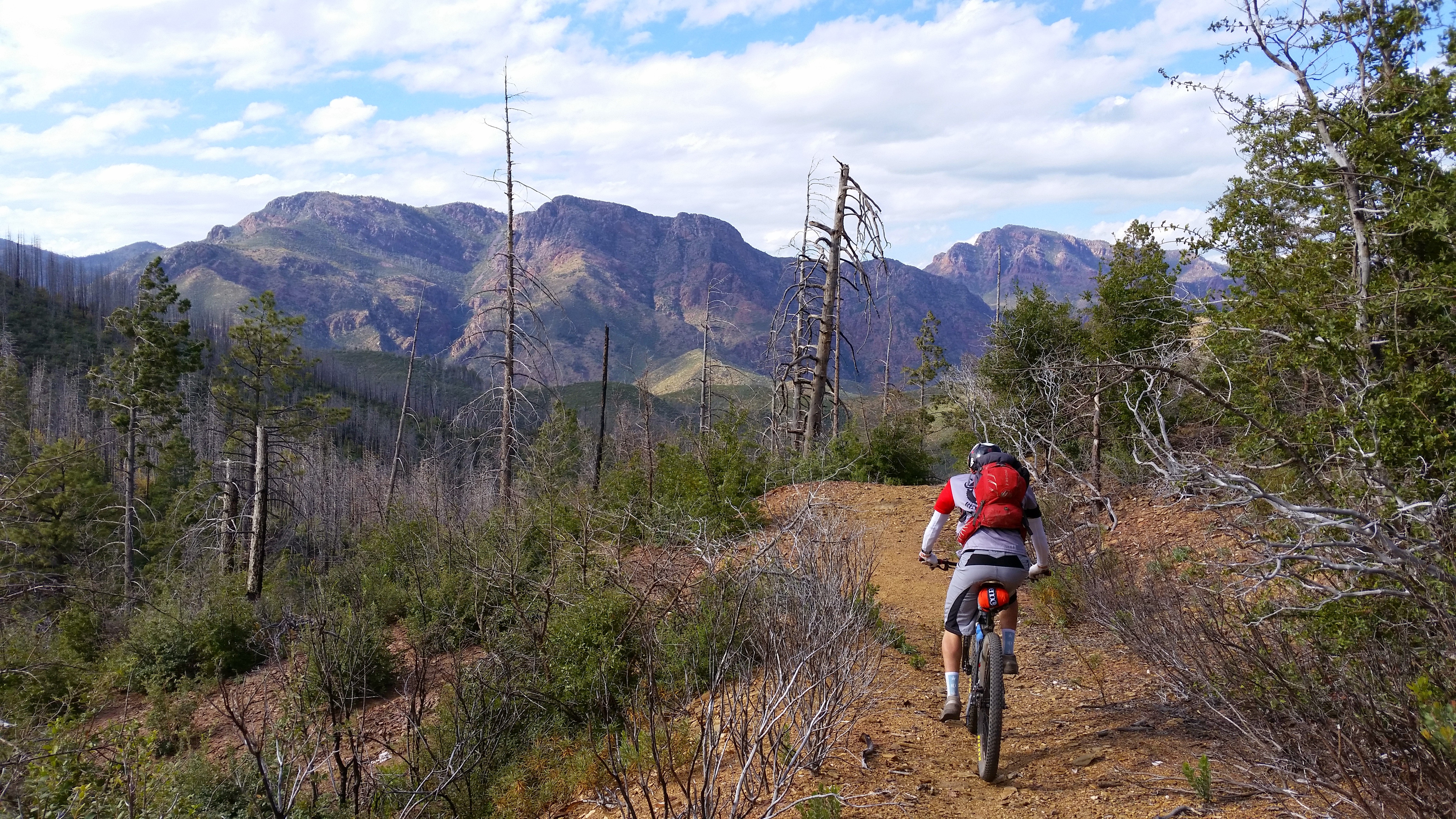
Out of Tucson, the race climbs the dirt Redington Road to the “side door” access of Mt. Lemmon, then on connecting 4×4 roads to the AZT coming out of the Rincon Mountains. Follow beautiful high desert singletrack on the Bellota and Molino trails, crossing the Catalina Highway and continuing to climb to Prison Camp.
At Prison Camp, the route begins a 3000 foot paved climb towards Summerhaven. *800 riders will continue on trail, climbing the following trails: Bug Spring, Green Mtn., Incinerator Ridge and Kellogg. The climbing tops out at Mt. Bigelow and begins a welcome descent towards Summerhaven via the Secret, 1918 & Sunset trails. At Summerhaven follow the Red Ridge Trail (hike-a-bike shoes on standby), then over to Oracle Ridge via Catalina Camp. Near the bottom pick up the Cody Trail, followed by more AZT through Oracle State Park to Highway 77. After a brief stint on Tiger Mine Rd, the Antelope Peak section of the AZT begins. After countless up and downhill switchbacks, the AZT climbs the crest the Black Hills, before dropping down to cross the sandy Bloodsucker Wash. More singletrack begins around the shoulder of Antelope Peak. This is a very remote stretch of Sonoran desert.
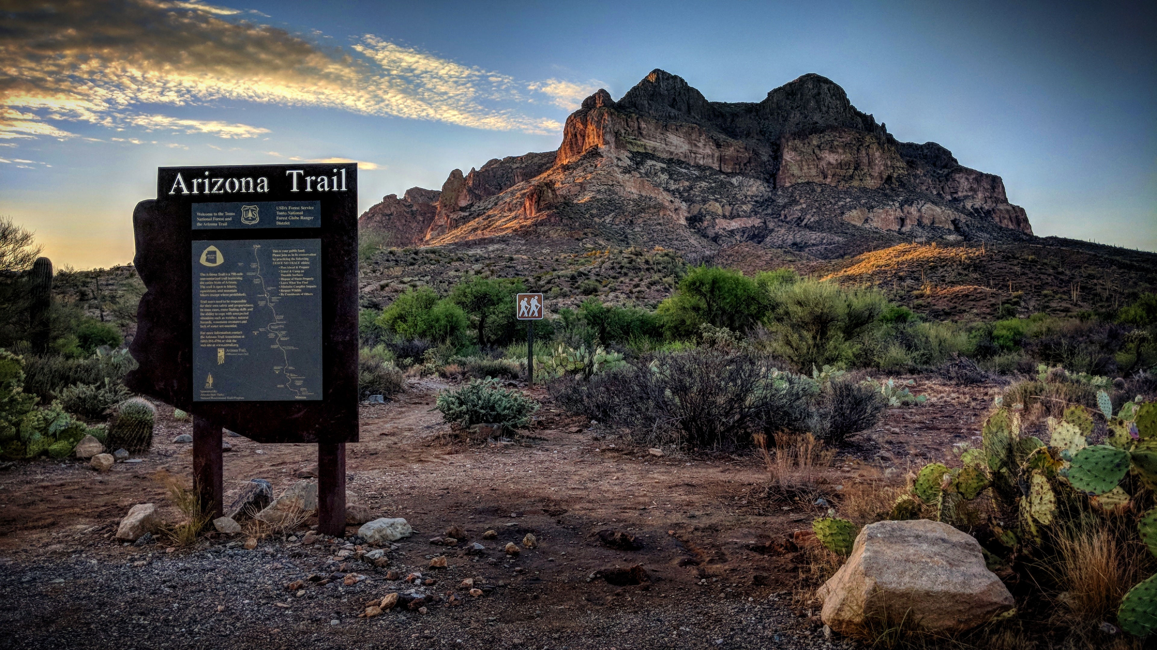
The AZT continues through the Boulders & Ripsey segments. Stunning desert scenery and quality switchbacks are the hallmarks of these trails. After the Boulders segment ends, the route continues onto the famous Ripsey ridgeline, where the views are huge and the climbing is painful. The route crosses the Gila River on an auto bridge in Kelvin, AZ, then starts a long singletrack section known as the “Gila River Canyons”. The Gila River Canyons traverse one of the most beautiful and colorful areas in the state, full of rhyolite formations and saguaro studded ridges. The Gila River Canyons connect to the Picketpost segment, aka Alamo Canyon, the traditional finish of the 300. The finish line is the hiker sign pictured below, at the Picketpost Trailhead.
Superior, AZ is 4 miles east on US 60. Food, motel, etc can be found there.
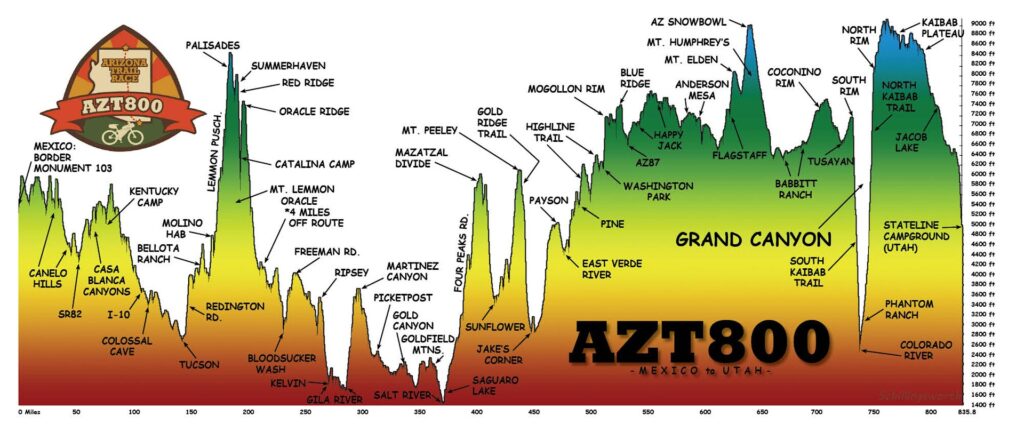
AZT800 Route Description
The AZT leaves Picketpost trailhead on singletrack for a couple miles. It then skirts the Superstition Wilderness by accessing a series of jeep roads. Resupply can be found in Queen Valley before returning to more remote jeep roads.
Connect to a fun maze of trails in Gold Canyon and then restock at the nearby shopping center. Horse trails and a bit of pavement lead to the Jacob Crosscut trail where stunning views of the Superstitions can be had. Cross AZ88 and follow a series of dirt roads & singletrack. Exit the Goldfield Mtns. via Bulldog Canyon. Follow pavement by Saguaro Lake (Snacks/water can be found at the marina) and pick up an OHV route linking into the graded 4 Peaks road. Climb away. At the summit the route joins the AZT for more jeep road traversing on the Mazatzal Divide. Singletrack takes riders down to Sunflower (No services) where it crosses AZ87. Water should be flowing in Sycamore Creek before Sunflower.
Ride about 5 miles of AZT on the north side of AZ87, then connect to pavement – remnants of the old Beeline Hwy. Begin a climb up dirt FS201 then veer off onto FS25 to FS25A for some rugged backcountry climbing. Shade and water can be found along West Fork Creek before joining the AZT once more along the Cornucopia Trail #86. The singletrack ends at the Mt. Peeley trailhead before resuming more dirt road along FS201. At the top look for the Gold Ridge Trail #47 and begin a 5 mile rowdy descent to the Deer Creek trailhead. Cross AZ87 and ride the 3 paved miles of AZ188 to Jake’s Corner. Take a dirt road spur to Rye, then begin the first in a series of rugged climbs.
The route goes through the center of Payson, then finds fast forest roads for a bit. The route becomes increasingly more rugged leading to Tonto Natural Bridge area. A short powerline corridor links back to the AZT where riders will stay until Utah. The trail is rugged leading into Pine. The re-routed Highline trail is now a highlight of Rim Country.
At Washington Park the trail turns north on the Colonel Devin trail and attains the Rim shortly thereafter. The Blue Ridge passage begins and the route is firmly planted in the tall trees. There are a couple of notable hike-a-bike sections here before the route crosses AZ87. Singletrack bypasses most of the rugged forest roads on the Happy Jack passage.
Cross Lake Mary road and continue north. Mormon Lake is slightly off route, but many riders use this as a resupply point. The trail continues north on singletrack and eventually crosses Lake Mary Road for a second time. Jeep roads await along with rocks & post-holing from free ranging cattle. Welcome to Anderson Mesa. The trail drops off the mesa and returns to blissful singletrack leading towards Flagstaff.
The route now utilizes the Mt. Elden passage and takes riders up Fisher Point and through Walnut Canyon. The trail climbs around the north side of Mt. Elden and rejoins the Flagstaff cutoff near Schultz Creek. The trail climbs steadily on the shoulder of Mt. Humphreys topping out near 9,000′ below Arizona Snowbowl ski resort. Enjoy a long methodical descent to the open ranch lands of Babbitt Ranch and more singletrack. The Coconino Rim brings singletrack riding all the way in to Tusayan and beyond.
Enter the Grand Canyon via bikepath, then a bit of singletrack leading to the South Kaibab trail. Focus on the task at hand, dismantle your bike, strap it to your back and begin the 21 mile trek to the North Rim. *The wheels must NOT touch the ground!! No exceptions. No napping on the trail, if you plan to snooze, you must obtain a camping permit for either Bright Angel or Cottonwood CGs*
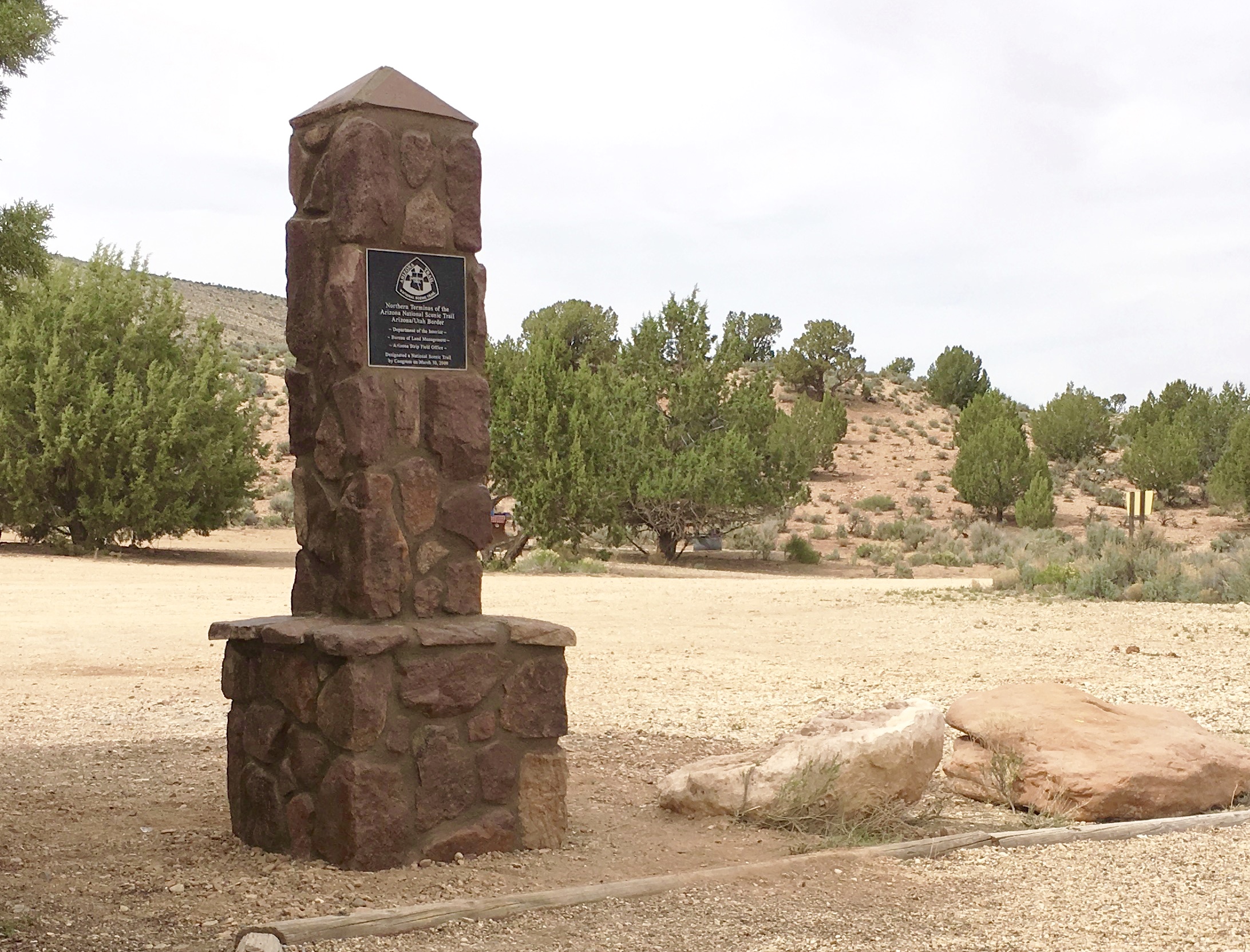
On the north side, the Kaibab Plateau offers forested singletrack and open meadow riding with some hike-a-bike mixed in. Jacob Lake is the last resupply, slightly off-route, roughly 30 miles from the finish. Cross US89A and begin a singletrack assault towards the Utah state line. Forested singletrack gives way to scrub meadows and a slow transformation of brown dirt to orange.
The final descent to Stateline drops some 1500′ over a few miles with a series of large radius turns. One last hill and the finish is in sight.
Congratulations, you just completed the AZT800!!