
This page is for…you guessed it: Frequently Asked Questions. Don’t let this be a substitute for your planning, perhaps a good place to start. FAQs aren’t in any particular order.
Q: When is the Grand Depart?
A: The 800 will be Thursday, October 1st, 2026 at 6:00am from near border monument 103. The 300 Grand Depart will remain on October 15th, 2026 at 6:00a. If you want to start your 300 on the 1st, you are welcomed to do so, same time & place as the 800.
Q: Where do I begin with planning?
A: Right here. Check the commonly asked questions, then dig into the website using the menus at the top. Please familiarize yourself with the rules of self-supported bikepack racing as it pertains to the AZTR. Download the most current GPX track. There are linked ride reports on the Results page. Dig into the ATA website, most of your questions can be answered there. Please consider becoming a member or make a donation. The trail depends on membership and donations to keep things running smoothly over 800 miles. Remember, the Arizona National Scenic Trail is very open and welcoming to mountain bikers. If you’re on social media, there’s an AZTR group that can assist with questions. Forums are also still in use, browse through recent posts on the Ultra Racing forum for more insight. For more general stoke, follow @azt300_800 on Instagram.
Q: When does registration open?
A: One month prior to the Grand Depart: Time TBD on September 1st, 2026 (AZ time, MST, which will be the same as Los Angeles). Registration link will be posted on the Announcements page.
Q: Is there a waitlist?
A: Yes. If the 60 rider limit is reached, that’s 60 riders combined for the 300 & 800, I’ll keep a waitlist. To avoid being on a waitlist, consider starting on a different day doing an ITT (Individual Time Trial). ITTs are highly encouraged and as long as the AZTR Rules are adhered to, your result will be tabulated and posted
Q: Is a tracker required?
A: No, but it is highly encouraged. SPOT units may be rented through Trackleaders or a personally owned device may be used. Garmin InReach devices also work with Trackleaders. Let family and friends follow your adventure, but please don’t ask them to meet you during your ride. Tracking intervals of either 5 or 10 minutes is preferred.
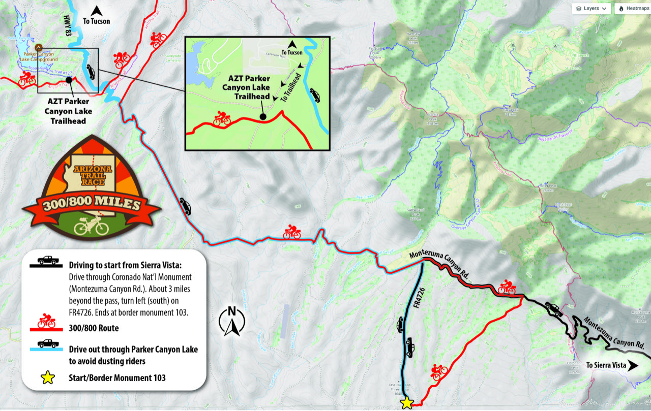
Q: Where is the start and what is the best way to get there?
A: The start for both the 300 & 800 is now at border monument 103. Both rides start at 6:00am local time. See pic below for driving directions. I kindly ask that you follow these directions for both dropping off riders and heading out, helps to avoid conflict between riders and vehicles and hopefully eliminates dust for the riders. Thank you!!
Q: Is there a shuttle service for 300 riders?
A: Yes!! Homegrown Shuttles is offering the service. More information & sign-up on the Homegrown Shuttles website. Finding True North also offers shuttle service, see their website.
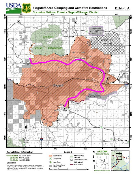
Q: Are there any camping restrictions?
A: Yes. Roughly between miles 606 (Fisher Point) – 642 (Snowbowl Rd.) near Flagstaff along the 800 route, no camping is permitted. For detailed information re: this closure go to the Coconino Nat’l Forest Alerts page.
Q: Are there shuttle options for 800 riders?
A: Check the ATA Website for shuttle availability from Stateline CG.
Q: What is the FKT for the 300? 800? Singlespeed?
A: FKTs are no longer being recorded. The course changes year-to-year along with potential fire/snow detours. There is a spreadsheet here that lists the past winners on one tab, all the course changes over the years on another, and a yearly list of everyone’s time splits.
Q: Is this route suitable for a gravel bike?
A: Short answer: No. Most riders choose either a full suspension or hardtail mountain bike. Some prefer rigid, others singlespeed. Go with what you like, but realize this is a very rugged and demanding route.
Q: How is the water reliability along the route?
A: Depends. A great place to start your water research is on the ATA website. While there, please consider becoming a member, the trail doesn’t exist without members and donations.
Q: Do I need to carry a water filter?
A: It is recommended. A lot depends on how much water you plan to carry. If you need/want to filter more frequently, expect some less than optimal water sources. Some sources may require pre-filtering. Consider other means of water treatment if high sediment is present.
Q: What GPS should I use?
A: There’s no perfect device, but many riders use a Garmin eTrex (AA batteries) or an Edge series (internal rechargeable battery). Coros Dura units have also become more popular.
Q: What are the best tires to use for the harsh desert terrain?
A: This is entirely open to personal preference, but whatever brand/model you choose, be sure they have sidewall protection and you carry extra sealant.
Q: What are the typical temperatures riders should expect?
A: Temperatures can and probably will vary widely, especially on the 800 route. Expect desert temperatures to be in the 80-100 range during the day, 40’s at night. Mt. Lemmon can drop below freezing at night. On the 800, daytime temps in the high country should be in the 50-65 range with nights falling below freezing. The North Rim could be in the teens at night. In short, plan for everything!! Hot to cold!! Be sure to check the 10-day forecast for towns along the route as the Grand Depart nears.
Q: How do I get a camping permit for the Grand Canyon if I don’t know when I’ll be arriving?
A: The Backcountry Office at the South Rim offers walk-up permits, if available, for both Bright Angel & Cottonwood Campgrounds. If permits are not available, inquire about the stock sites at each campground for AZT through travelers. *Remember: permits are required if you plan to sleep below the rim. No napping on the trail. If you don’t have a permit, you are expected to complete the full rim-to-rim hike in one push. No exceptions, zero tolerance. This also goes for the bike portage of the trek, wheels can NOT touch the ground. Bikes must be disassembled and carried, absolutely no riding or rolling below the rim.
Q: I have more questions about the Grand Canyon.
A: Check out the Grand Canyon AZT Stewards resource website.
Q: How do I affix my bike & gear to a backpack for the Grand Canyon portage?
A: There have been a few variations over the years, but most prefer to use a pack with a wire frame for support. A great resource, while now dated, is still very relevant and offers a few links to what others have used. Carrying a bike via backpack NOTE: The bike must be disassembled for the portage, no complete bike carries.
Q: Do I need any other permits for the ride?
A: Yes. An individual recreation permit for State Trust Land may be purchased online here. While there is a 15′ corridor easement along the AZT as it traverses State Trust Land (no permit needed for this), however both the 300 & 800 cross State Trust Land for the Wilderness bypasses when the route leaves the AZT.
Q: Any other special use areas along the route?
A: Yes. For both the 300 & 800, the AZT passes through private ranch land and the trail is only open between sunrise and sunset. Please respect this and adjust your start time if necessary when doing an ITT (Individual Time Trial). The area is approximately located between miles 52.3 – 54.1 of both routes, the final 2 miles before reaching SR82 north of Patagonia. If you can’t make it to SR82 before sunset, find a camp location before mile 52. Alternately, if you want to keep moving forward on route, but won’t make the sunset closure you have the option to remain on the legacy AZT to Patagonia, then rejoin the route as it crosses SR82. The gpx for this option is posted separately and is longer, slower and more difficult. Use Timeanddate.com for exact sunset times for Patagonia. Any violation of this sunset rule is an immediate DQ. No exceptions. This is NOT a daylight closure, you must be completely through this area BEFORE sunset and do not enter before sunrise. Thank you.
Q: Can we use the bear boxes, aka public water caches, along the AZT?
A: Technically, yes. However, this is discouraged. Being a bike rider, we can cover much more ground than a hiker and they are more dependent on the cache boxes than we are. If you do use water from a cache box, please DO NOT use water marked with someone’s name on it!! Their life may depend on it. Don’t plan on water being available at all and definitely DO NOT arrive at a cache box dry. Please, please use sparingly. If any water is dropped off at a cache box prior to the AZTR, it MUST be marked as PUBLIC water. Again, don’t rely on it being there.
Q: Where can I find ride stoke?
A: Right here. Aaron Johnson has completed both the old 750 and the current 800 routes and was inspired enough to create wonderful video recaps of both. Here is a link to the 800 route from the 2024 Grand Depart and here is a link to the 750 route (still applies in some fashion) from the 2014 Grand Depart. Enjoy!!
Q: What is this MTBCast I keep hearing about?
A: It’s a free service to call this number: 888-866-4491 and leave a message. Tell us how it’s going out there. Doesn’t have to be life changing, or maybe it is. The good, bad, ugly, funny or just to say Hi!! Do it, we want to hear from you and how the ride is treating you.